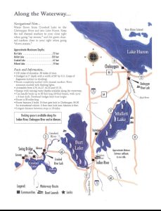
The Inland Waterway stretches across Cheboygan and Emmet Counties has been a popular recreation area for years. Fishing, paddling watercrafts and motorboats all travel the waterways. The route is a series of 3 rivers and 3 lakes. You can start at north end, the mouth of the Cheboygan River at Lake Huron and follow that to Mullet Lake. During your trip on the Cheboygan River you will encounter the Cheboygan River lock which will raise or lower your boat 15 feet. Mullet Lake will lead you through the Indian River and into Burt Lake. From there you will head down the Crooked River which also has a lock that depending on water levels the Crooked River Lock will lower boaters between 3 to 12 inches. As you leave Crooked River you enter the last of the waterway, Crooked Lake. Once on Crooked Lake you can take the ½ mile Black Hole Channel that connects to Pickerel Lake. Crooked Lake also connects to Round Lake via Round Lake Creek. This creek is not very navigable and can dry up in the summer.
Just 2 miles west of Crooked lake is Little Traverse Bay on Lake Michigan in Petoskey. Unfortunately, the water trail stops with Crooked Lake without access to Lake Michigan.
During your travels you will have a chance to stop and visit many communities along the route. Cheboygan, Mullet Lake Village, Aloha, Topinabee, Indian River, Burt Lake, Alanson, Ponshewaing, Oden and Conway.
Before the Waterway was filled with pleasure boaters it was a crucial route for Native Americans and later Fur Traders and loggers.
The Anishinaabe (Odawa, Ojibway and Potawatomi) would use the waterway to move between communities they were trading with. It was also a source of food and fresh water. There were permanent Native American settlements all along the waterway route.
In the late 18th century, Samuel Robertson was the first European to live in the area and would trade with the local Native Americans.
 May parts of the waterway were only navigable by the smallest watercrafts because of numerous sand bars along the route. The mouth of Cheboygan Rivers had a large sand bar as it emptied into Lake Huron. Add in the rapids about a mile down the river that were a hazard to traveler, most of the Cheboygan River was barely passable with a canoe.
In the mid-19th century the area was changing and the first sawmill was built in Cheboygan. In order to use the power of the river for the sawmill the owner, Alexander McLeod along with his brother Ronald built a dam at the rapids up the river. This made it more difficult to navigate the river especially for larger vessels.
As Cheboygan and the lumber industry grew in the Northeast, it was decided to make improvements to what would be one of their major arteries. The lock was first build in 1869 and starting in 1874 sand bars were removed making the waterway easier to navigate. This made it possible for lumber to float down the river to sawmills along the route and eventually make their way to Lake Huron for deliver to other ports. The lock was rebuilt in 1927 to allow larger vessels.
In the late 19th century railroads were introduced to the north and the Inland Waterway commercial use dropped off. As more people came north, the Waterway became a tourist destination.
Tourists arrived from all over Michigan and the U.S. to explore and enjoy the beauty of the area. Resorts were built along the route and pleasure cruises became popular. Many departed from Cheboygan and stopped at the resort communities along the way. Some of the ships were owned by individual resorts to provide cruises for their guests.
In the early 20th century, the area faced a rapid depopulation and rail, and boat traffic were reduced. The area’s economy suffered as fewer people traveled the inland route. As automobiles became popular tourists started returning buying cottages and boats or staying in resorts. Today, thousands and thousands of boaters enjoy the Inland Waterway.
Inland Waterway Historical Marker
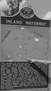 Civil War and After (1860-1875) – Registered in 1957 and erected in 1957 – ID #S127
Located in Burt Lake State Park, Indian River, Tuscarora Township – Lat: 45.40254800 / Long: -84.62339400
The glaciers of the last Ice Age retreated to the north some twenty-five thousand years ago, leaving behind the lakes that rank as Michigan’s most notable geographical feature. Among the state’s largest inland lakes is Burt Lake, named after William A. Burt, who, together with Henry Mullett, made a federal survey of the area from 1840 to 1843. By following the Cheboygan River, Mullett Lake, and Indian River to Burt Lake, then up Crooked River to Crooked Lake, Indians and fur traders had only a short portage to Little Traverse Bay. Thus they avoided the trip through the Straits. Completion of a lock on the Cheboygan in 1869 opened this inland waterway to the Cheboygan Slack Water Navigation Company, whose vessels carried passengers and freight until railroads put it out of business. Day-long excursions over these waters became popular with tourists.
Round Lake Head of the Inland Waterway
Lock Schedule and Waterway Guide and Navigational Charts
Inland Water Route Historical Society
Learn more about the rich history of the Northeast Lower Peninsula.