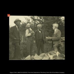
The Vagabonds Land in the U.P. On this day in history—August 17, 1923—three of America’s most iconic innovators set foot in Michigan’s Upper Peninsula. They arrived for a camping trip that was anything but rustic. Henry Ford, Thomas Edison, and Harvey Firestone, along with their wives, friends, and an entourage of staff, arrived in Escanaba aboard Ford’s massive luxury yacht, Sialia. The group, known as “The Vagabonds,” wasn’t just on a vacation—they were making history. The Sialia, a 300-foot sea-going vessel equipped with every modern safety and comfort feature, cruised through dense fog across Lake Michigan after a tour of… Read More »